I recently helped a friend who was looking to buy a piece of raw land. I started researching the property the same way I always have and quickly ran into the same problems I’ve dealt with for years. The information was technically out there, but finding it was frustrating, scattered, and confusing. One website would lead to another, some looked official but weren’t, and after spending time digging through maps and data you’d suddenly realize you needed to pay just to keep going.And that was just for one type of information.That experience is what led to the idea behind Dirt Data.There are plenty of websites that offer impressive maps and layers, but very few actually explain what the information means in practical terms for the average person looking to buy property. Understanding flood zones, soil conditions, elevation changes, zoning, drainage, or possible site constraints can get overwhelming fast if you don’t already work in construction, development, or land planning.Dirt Data was created to simplify some of those early-stage property questions through builder-informed snapshot reports designed to help people better understand a piece of property before spending significant time and money moving deeper into the process.As Dirt Data grows, I’ll continue improving the reports and adding new report types that may help buyers make more informed decisions.My goal is simple: provide practical information that helps people avoid costly surprises before buying land.Any feedback is appreciated, and if you need a custom report feel free to reach out.— Don Burns
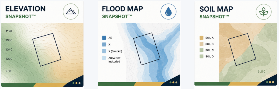
Buying land or evaluating property often means sorting through fragmented public data spread across multiple county, GIS, FEMA, soil, and zoning websites. For many buyers, investors, and property owners, understanding what information actually matters can quickly become overwhelming.Dirt Data was created to help simplify that process by organizing complex property information into clear, visual, easy-to-understand snapshot reports designed for early-stage property evaluation.The goal is not to replace engineers, surveyors, or governing jurisdictions — but rather to help property buyers better understand what questions to ask before investing significant time, money, or development planning into a site.
Dirt Data reports are shaped through real-world building, site, and property development experience.Rather than simply displaying raw mapping layers or technical data, the reports are designed to help identify observable conditions, potential constraints, and practical property considerations that may impact future usability, development potential, drainage behavior, flood exposure, or overall project complexity.This practical perspective helps bridge the gap between publicly available data and real-world property decision-making.
Dirt Data reports are preliminary desktop-level informational reports intended for early-stage property research and observational review.These reports are not:engineering studiesboundary surveyspermitting approvalslegal zoning determinationsenvironmental certificationsgeotechnical reportsconstruction documentsguaranteed feasibility determinationsAll users are strongly encouraged to independently verify property conditions, zoning regulations, environmental constraints, permitting requirements, utility availability, and development feasibility directly with governing jurisdictions and licensed professionals prior to acquisition or development decisions.
Learn more about Dirt Data snapshot reports including:Elevation Snapshot™Flood Map Snapshot™Soil Map Snapshot™Zoning Snapshot™Development Window Snapshot™
EXPLORE REPORTS